Conowingo Dam
Yesterday, John and I took our cameras (and his new lens) to Conowingo Dam. We had heard of eagle sightings and went for a long drive in hopes of seeing one.
Conowingo Dam is rather interesting in and of itself.
The Conowingo Dam (also Conowingo Hydroelectric Plant, Conowingo Hydroelectric Station) is a large hydroelectric dam in the Lower Susquehanna River. The dam, one of the largest non-federal hydroelectric dams in the US, is classified as a medium height, masonry gravity type dam. The dam is located in Maryland, spanning the Cecil and Harford county border — 9.9 miles (14.6 km) from the river mouth at the Chesapeake Bay, about 5 miles (8 km) south of the Pennsylvania border and 45 miles (70 km) northeast of Baltimore.
The dam is named for the town of Conowingo, Maryland. The original location of Conowingo is now under the waters of the reservoir created by the dam. The town was relocated during construction of the dam to its present location about 1-mile (1.6Â km) northeast of the dam’s eastern end. The area, as per the 1612 John Smith map, was originally known as Smyth’s Falls.
Conowingo Dam also serves as a bridge for U.S. Route 1 across the Susquehanna River. The original Route 1 crossing, Conowingo Bridge, would have been submerged after the completion of the dam, so it was demolished in 1928. The Conowingo Reservoir, and the nearby Susquehanna State Park, provide many recreational opportunities.

This particular day however, there wasn’t much water coming out.
We did see an Eagle Perched on a tower:

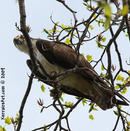
But one of the highlights of the day for me, was this osprey playing peek-a-boo.

Love those eyes!


Nice shot of the Osprey. The best time to go to the dam is Oct/Nov. The BE’s flock there formating season. Problem is so do the photogs. At peak time they almost need traffic monitors for the crowd.